JULY 5, 2024 by Chinese Academy of Sciences
Collected at: https://techxplore.com/news/2024-07-beidou-satellite-significant.html
The BeiDou Navigation Satellite System (BDS) is undergoing a significant upgrade to meet the burgeoning needs for high-precision positioning across various sectors. The new services aim to provide decimeter-level accuracy within minutes, a substantial improvement over the current capabilities.
This advancement is crucial for emerging technologies such as autonomous driving, robotic navigation, and smart city infrastructures, which rely on reliable and precise location data for effective operation.
With the rapid growth of technologies like autonomous driving and robotic navigation, the demand for highly accurate and reliable positioning systems has surged. Traditional systems such as Global Positioning System (GPS), GLObal NAvigation Satellite System (GLONASS), and Galileo have set high standards, but challenges like limited regional coverage and long convergence times remain.
These issues underscore the need for enhanced navigation satellite systems. The BeiDou Navigation Satellite System (BDS) aims to address these challenges by improving its high-precision services, making it a vital player in the global positioning landscape.
Researchers from the Beijing Institute of Tracking and Telecommunication Technology, in collaboration with the Shanghai Astronomical Observatory and Wuhan University, have published a study in the journal Satellite Navigation. Released on 24 June 2024, the study details the BeiDou system’s high-precision services, outlining its current state, achievements, and future trajectory.
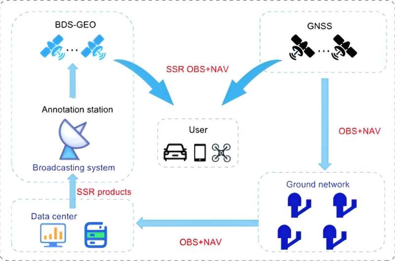
The study examines BeiDou’s high-precision services, focusing on the PPP-B2b of BDS-3, which achieves decimeter-level accuracy within 14 minutes. Despite its advancements, BDS-3 lags behind international counterparts like Galileo’s High Accuracy Service (HAS) and Quasi-Zenith Satellite System’s (QZSS’s) Centimeter-Level Augmentation Service (CLAS) in regional coverage and convergence time.
To address these limitations, the research proposes a multi-layer development framework, emphasizing the integration of low Earth orbit (LEO) satellites. Incorporating a LEO constellation of 288 satellites can improve positioning accuracy to better than 5 cm within approximately 1 minute, enhancing global coverage and significantly reducing convergence time.
Simulation results demonstrate that LEO-enhanced PPP services can achieve rapid and precise positioning, overcoming current limitations and positioning BeiDou as a leader in high-precision satellite navigation.
Dr. Xingxing Li from Wuhan University stated, “The advancements in BeiDou’s high-precision services are pivotal for meeting the escalating demands of modern navigation applications. The integration of LEO satellites is particularly promising, as it significantly enhances coverage and reduces convergence time, bringing us closer to achieving real-time, centimeter-level positioning accuracy on a global scale.”
The enhanced BeiDou high-precision services have profound implications for various applications, including autonomous driving, unmanned aerial vehicles, and smart device navigation. The proposed improvements in global coverage and convergence time will enable more accurate and reliable positioning solutions, fostering innovation and efficiency in these fields.
This progress represents a significant step forward in the evolution of global navigation satellite systems, positioning BeiDou as a leader in high-precision services.
More information: Weiguang GAO et al, High-precision services of BeiDou navigation satellite system (BDS): current state, achievements, and future directions, Satellite Navigation (2024). DOI: 10.1186/s43020-024-00143-8
Leave a Reply