Mark Patrick – July 24, 2024
Collected at: https://www.iotforall.com/harnessing-satellite-data-to-promote-sustainable-agriculture
As the global population continues to grow, the issue of food security becomes more pressing. Increasing agricultural production is a crucial challenge, especially considering its vulnerability to factors like extreme weather events, deforestation, resource scarcity, and urbanization, which further diminish the available workforce. This is where sustainable agriculture comes in.
Unfortunately, agriculture also adds to its challenges since it currently accounts for 19–29 percent of all greenhouse gas emissions. Nearly three-quarters of the world’s poor live in rural areas, where agriculture struggles as people migrate to cities.
Smart agriculture has started elevating yields and farm profitability while reducing resource requirements and environmental impact. Agricultural operations globally are now incorporating soil sensors, robotics, and automation into their farms, all supported by artificial intelligence (AI) or machine learning (ML).
These tools offer unparalleled insights, empowering farmers to proactively anticipate and adjust to forthcoming changes.
Understanding Smart and Regenerative Agriculture
Smart agriculture, regenerative agriculture, and rewilding are crucial concepts in addressing the pressing challenges of land degradation, environmental restoration, and food security. By incorporating advanced technologies such as satellite imagery, automation, and wireless soil sensors, the goal of smart agriculture is to improve farming methods, increase resource efficiency, and achieve sustainable agriculture.
The significance of these approaches for society cannot be emphasized enough, given that almost one-third of the world’s arable land has been lost due to erosion or pollution in the past four decades, and the United Nations has issued a warning that 90 percent of Earth’s topsoil will be at risk by 2050.

However, implementing smart agriculture comes with its challenges, such as escalating agricultural costs, limited accessibility to resources, and the need for widespread social, economic, and regulatory changes.
The Role of Space Technology in Agriculture
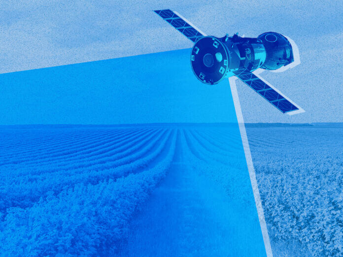
The technologies that can revolutionize our farms are not limited to on-site solutions. Some of the most impactful advancements are found miles away, such as the European Space Agency’s (ESA) Soil Moisture and Ocean Salinity (SMOS) mission, which monitors certain geophysical characteristics from a satellite orbiting 471 miles above Earth.
Satellite imagery is a cornerstone of sustainable agriculture, providing a view of vast agricultural landscapes. This technology enables farmers to monitor land use, identify areas of degradation, and assess crop health with unprecedented accuracy.
Furthermore, climate monitoring through satellite data facilitates early detection of environmental stressors such as droughts, floods, and extreme weather events, empowering farmers to implement timely interventions and adapt their practices accordingly, ensuring resources are deployed effectively.
ESA contributes to the progress of smart and regenerative agriculture through its involvement in satellite data initiatives. For locations across the globe, ESA has gathered weekly and even daily images that can offer incredible insight.
By examining these images side by side, you can witness the evolution of the land over time, offering a glimpse into the consequences of changing climates, past extreme weather events, and human-made disasters.
In the past, utilizing data sets as extensive as those provided by ESA has been complex and costly, restricting potential applications for agriculture. However, with enhanced computing power and progress in large-data modeling and AI, it has become feasible to use and exploit this data to propel a broader spectrum of farming techniques.
ESA’s SMOS Mission
The SMOS mission, launched in 2009, is focused on collecting worldwide data on soil moisture levels on land and salinity levels in the oceans. SMOS is playing a vital role in advancing our comprehension of the exchange processes between the Earth’s surface and atmosphere.
It also aids in the enhancement of weather and climate models by consistently mapping crucial components in the water cycle.
The SMOS satellite carries a unique interferometric radiometer, operating in the L-band microwave range to capture images of ‘brightness temperature’ by capturing surface radiation emission. These images are used to create accurate global maps of soil moisture, with a precision of 4 percent at a spatial resolution of approximately 50km.
Farmers can use this information to identify areas of overwatered or underwatered land and to receive warnings about drought or water stress.
Recently, data from SMOS has been used to drive other areas of smart agricultural modeling. Due to the escalating prominence and severity of wildfires, ESA and the European Centre for Medium-Range Weather Forecasts have been collaborating to merge SMOS data with Canadian fire weather index data.
We combine satellite data and remote sensing to identify high-risk forest fire areas, resulting in a Fire Occurrence Probability Index (FOPI) ranging from 0 to 1. A value above 0.8 indicates extreme danger, while 0 signifies no danger. This helps in implementing preventive measures and understanding the causes and behavior of fire.

ESA’s Collaborative Role
ESA provides satellite images and collaborates directly with external organizations on smart agriculture. The UN International Fund for Agricultural Development (IFAD) has been collaborating with ESA since 2010 to showcase the power of Earth observation in agricultural applications.
This collaboration created land cover maps in Madagascar, monitored pasture health in Kyrgyzstan, mapped erosion in Lesotho, and identified vulnerable areas in Tajikistan.
ESA’s remote sensing expertise and data will help IFAD’s agricultural programs design and refine their geographic targeting. Additionally, it will aid in monitoring natural resources such as pastures, forests, water, and soils, which are vital to the livelihoods of smallholder farmers.
ESA and the UN are expanding this initiative to include livestock migration, afforestation, and IFAD’s new agroecology program.
Copernicus Programme and Future Developments
The provision of accurate, timely, and easily accessible information is crucial to enhancing environmental management. It helps us understand climate challenges affecting farming and society, enabling us to navigate them more effectively and reach sustainable agriculture goals.
Going beyond SMOS, the European Union’s ambitious Copernicus Programme uses satellites, ground-based measurements, and advanced technology. This combination effectively monitors and controls various elements of the Earth’s environment.
Key components of the Copernicus Programme include ESA’s Sentinel satellites, the backbone of Earth observation activities.

These satellites monitor land use, vegetation health, soil moisture, temperature, and weather patterns, crucial for Earth’s environment. This comprehensive observation provides valuable data for leveraging in smart agriculture practices.
Satellite data lets farmers track land use changes, including crop growth, land cover, and vegetation health. It enables early crop stress or disease detection, optimizing irrigation and fertilization, and making informed decisions to maximize yields.
Farmers can use combined satellite and ground sensor data to generate real-time soil moisture and temperature information.
The program aids weather forecasting and climate monitoring by collecting data on atmospheric conditions, temperature, and precipitation. It helps track livestock and monitor pests, allowing farmers to plan activities and reduce crop damage.
Integrating satellite data with precision agriculture technologies enables precise application of water, fertilizer, and pesticides using GPS/GNSS and drones. Smart optimization strategies help minimize waste, risk, and environmental impact while maximizing efficiency.
Future Developments
The Copernicus Programme’s data is already fueling advanced agricultural and environmental modeling, and even more complex initiatives are emerging quickly.
Integrating ground, undersea, and ESA technologies, the European Digital Twin of the Ocean (European DTO) creates a functional ocean replica. This model aids experts in restoring Europe’s seas and oceans, focusing on sustainability and protecting marine biodiversity.
Expanding data and computing capacity are advancing an exceptionally precise digital replica of the Earth. Through this model, we can effectively tackle environmental and agricultural issues.
Endless Capabilities
The monitoring capabilities of satellites like those within the Copernicus program offer valuable insights and tools for smart agriculture. Through data-driven decision-making, efficient resource management, and adaptation to environmental changes, farmers can practice sustainable and efficient agriculture.
This benefits the environment and society, helping governments support initiatives like regenerative agriculture and forest fire prevention. ESA’s work may not seem impactful now, but it has already had substantial effects and will grow in the future.
Soil sensors, automation, AI, and advanced modeling will boost space-based technology’s role in crisis prevention and food supply.
Leave a Reply