MAY 28, 2024 by Aerospace Information Research Institute, Chinese Academy of Sciences
Collected at :https://techxplore.com/news/2024-05-high-precision-ambiguity-resolution-method.html
A cutting-edge method for Global Navigation Satellite System (GNSS) ambiguity resolution has been developed, promising to enhance the accuracy and reliability of urban positioning. This innovative approach addresses the longstanding challenge of obtaining precise location data in built-up environments where signals are often obstructed.
Accurate Global Navigation Satellite System (GNSS) positioning in urban environments faces significant challenges due to multipath effects, signal blockages, and frequent outliers. Traditional methods like integer least squares (ILS) and Gaussian Best Integer Equivariant (GBIE) often struggle to maintain reliability under these conditions.
Improved ambiguity resolution techniques are urgently needed to manage these urban-specific issues effectively. Therefore, advanced methods for GNSS ambiguity resolution are crucial for enhancing positioning accuracy and reliability in urban settings.
Researchers from Wuhan University have introduced an improved Best Integer Equivariant (BIE) estimation method with Laplacian distribution, a significant advancement in the field of satellite navigation. Published in the Satellite Navigation journal on 20 May 2024, the study presents a detailed analysis of this new method, which is designed to improve urban low-cost Real-Time Kinematic (RTK) positioning.
The study introduces an enhanced BIE estimation method that incorporates Laplacian distribution, addressing limitations of GBIE and ILS methods. Key innovations include a new weight function for Laplacian BIE (LBIE) and a criterion based on the optimal integer aperture (OIA) test to select candidates for BIE estimation.

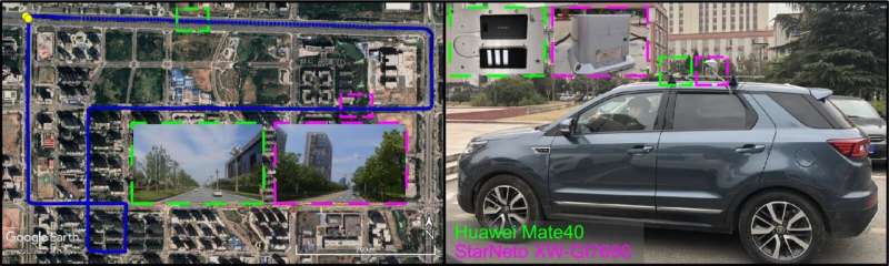
Field tests in urban environments using a Huawei Mate40 smartphone and a low-cost GNSS receiver STA8100 showed that the LBIE method achieved positioning errors under 0.5 meters in three directions during an urban expressway test, improving over 50% compared to ILS-PAR and GBIE methods.
In an urban canyon test, LBIE demonstrated positioning accuracy of 0.112 meters, 0.107 meters, and 0.252 meters in east, north, and up directions, respectively, with substantial improvements over traditional methods.
These findings underscore LBIE’s superior performance in urban environments, effectively handling heavy-tailed error distributions common in such settings. The study’s innovations promise to enhance the reliability and accuracy of GNSS applications in challenging urban conditions.
Dr. Wanke Liu, lead researcher from Wuhan University, stated, “The integration of Laplacian distribution into the BIE estimation represents a significant breakthrough in urban GNSS positioning. This method’s ability to handle outliers and unmodeled errors improves positioning accuracy, making it a valuable tool for various urban GNSS applications.”
The improved GNSS ambiguity resolution method enhances urban navigation and positioning accuracy, impacting fields like autonomous driving, urban planning, and location-based services. This method’s reliability in urban environments opens new possibilities for advanced GNSS applications, promoting smarter urban management. Future research will refine parameters and integrate other sensors to further boost performance in dynamic urban settings.
More information: Ying Liu et al, An improved GNSS ambiguity best integer equivariant estimation method with Laplacian distribution for urban low-cost RTK positioning, Satellite Navigation (2024). DOI: 10.1186/s43020-024-00134-9
Leave a Reply