By James R. Riordon on OCTOBER 26, 2022
Muons from cosmic rays might lead to a new tool for understanding the weather
Particles raining down from space offer 3-D views inside swirling tropical storms.
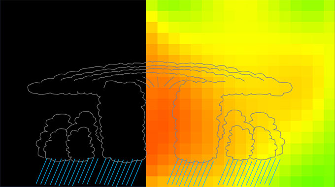
Muons created from cosmic rays that smash into Earth’s upper atmosphere have revealed the inner workings of cyclones over Japan, researchers report October 6 in Scientific Reports. The new imaging approach could lead to a better understanding of storms, the researchers say, and offer another tool to help meteorologists forecast the weather.
“Cosmic rays are sustainable natural resources that can be used everywhere on this planet for 24 hours [a day],” says geophysicist Hiroyuki Tanaka of the University of Tokyo, so it’s just a matter of taking advantage of them.
Science News headlines, in your inbox
Headlines and summaries of the latest Science News articles, delivered to your email inbox every Thursday.E-mail Address*SIGN UP
Muons offer a glimpse inside storms because variations in air pressure and density change the number of particles that make it through a tempest. By counting how many muons arrived at a detector on the ground in Kagoshima, Japan as cyclones moved past, Tanaka and colleagues produced rough 3-D maps of the density of air inside the storms. The approach gave the team an inside look at the low-pressure regions at the centers rotating storm systems.
Muons, which are similar to electrons but roughly 200 times as massive, can scatter off molecules in the air. They’re also unstable, which means they break down into electrons and other particles called neutrinos given enough time. As air pressure increases, so does its density. That, in turn, increases the chances that a muon born from a cosmic ray will be bumped off its path on the way toward a detector or get slowed enough that it breaks down before it makes it all the way through the atmosphere.
For every 1 percent increase in air pressure, Tanaka and colleagues say, the number of muons that survive passage from the upper atmosphere to the ground decreases by about 2 percent.

Tanaka has previously used muons from cosmic rays to look inside volcanoes, and he suspects that others have used the particles to study weather (SN: 4/22/22). But, he says, this appears to be the first time that anyone has made 3-D muon scans of the insides of a storm.
“It is an interesting approach,” says meteorologist Frank Marks of the National Oceanic and Atmospheric Administration’s Atlantic Oceanographic and Meteorological Laboratory in Miami, who wasn’t involved in the research.
Subscribe to Science News
Get great science journalism, from the most trusted source, delivered to your doorstep.
He doesn’t expect muon imaging to replace conventional meteorological measurements, but it’s another tool that scientists could use. “[It] would be complementary to our existing techniques to provide 3-D mapping of the storms with our other traditional observing systems, like satellites and radar.”
Questions or comments on this article? E-mail us at feedback@sciencenews.org
CITATIONS
H.K.M. Tanaka et al. Atmospheric muography for imaging and monitoring tropic cyclones. Scientific Reports. Vol. 12, October 6, 2022. doi: 10.1038/s41598-022-20039-4.

Leave a Reply